How drone is used in agriculture?
Apr 01 , 2022Agricultural plant protection farm drones for sale are a versatile device. Used in agriculture, planting, forestry and other industries. In the process of use, its role is not single, but various. For example, in the agricultural industry, agricultural plant protection drones can realize sowing, fertilization, and pesticide spraying. Their uses are quite extensive. Next, let's talk about the use of agricultural plant protection drones in agriculture.
Farmland irrigation
During the growing process of crops, farmers must know and adjust the soil moisture suitable for crop growth anytime and anywhere. Use the agricultural plant protection drone to fly over the field to observe the different color changes of the farmland soil under different humidity. Make a set of digital maps and store them in the database, so that we can use the information obtained from the aerial photography of agricultural plant protection drones to identify and compare the information stored in the database, and solve scientific and reasonable irrigation problems. In addition, agricultural plant protection smart agriculture drone can also be used to observe the withering of plant leaves, stems and twigs caused by insufficient soil moisture in farmland, as a reference for judging whether crops need irrigation and watering, so as to achieve the purpose of scientific irrigation and water saving.
Farmland information monitoring
Agricultural plant protection drone smart farming farmland information monitoring mainly includes pest and disease monitoring, irrigation monitoring and crop growth monitoring. It uses spatial information technology mainly based on remote sensing technology to take aerial photos of large areas of farmland and land, and comprehensively and comprehensively understands the growth environment and cycle of crops from aerial photos and video data. Problem areas that cannot be detected by the naked eye, such as pests and diseases, bacterial invasion, are convenient for farmers to better manage their fields. UAV farmland information monitoring has the advantages of wide scope, strong timeliness, objective and accurate, etc., which is beyond the reach of conventional monitoring methods.
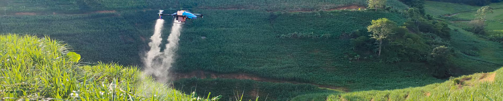
Agricultural Insurance Survey
During the growing process of crops, they will inevitably be attacked by natural disasters, causing losses to farmers. For farmers with small crop areas, regional surveys are not difficult, but when large areas of crops are damaged by nature, the workload of crop surveys and loss assessments is enormous, and it is difficult to accurately define the problem of lost areas. In order to more effectively measure the actual disaster area, agricultural insurance companies have carried out agricultural insurance disaster loss surveys and applied drones to agricultural insurance claims. UAVs have technical characteristics such as flexibility, rapid response, high-resolution image and high-precision positioning data acquisition, application expansion of various mission equipment, and convenient system maintenance, and can perform disaster loss determination tasks. Through post-processing and technical analysis of aerial survey data and aerial photos, as well as comparison and correction with on-site measurement results, insurance companies can more accurately determine the actual disaster-affected areas. Drones are affected by disasters and damage. The agricultural plant protection drone solves the problems of difficult damage determination and weak timeliness in agricultural insurance claims survey, greatly improves the survey speed, saves a lot of manpower and material resources, and ensures the accuracy of claims while improving the claim rate. Improve farmland compensation surveys.
The operation of agricultural drones is very simple. The grower in the field only needs to press the corresponding button through the remote control, and the aircraft will complete the corresponding action. In addition, the aircraft also has the function of "flying on the ground", which can automatically maintain the height between the fuselage and the crops according to the changes of the terrain, so as to keep the height unchanged.


 IPv6 network supported